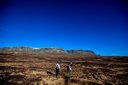
Summer in Haugastøl offers great opportunities not only for cycling the Rallarvegen but hiking too. The surrounding area with the two national parks Hallingskarvet and Hardangervidda offer walks suitable for every level.
Here are a few of our recommended options:
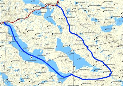
Haugastøl - Krækkja - Fagerheim
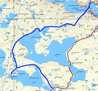
Length: 18 km
Map: can be bought in the reception at Haugastøl.
The track starts about 200 meters west along RV7 from Haugastøl. It is marked by red T's and goes past the Øvre and Nedre Trestiklan Lakes down to the Krækkja Cabin. Onwards from here the path leads you along the northend of the Storekrækkja lake towards Fagerheim. To return to Haugastøl you are dependent on buses or other transport.
Haugastøl - Tuva - Ustaoset
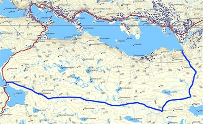
Map: can be bought in the reception at Haugastøl.
Catch a bus or park your car by Lægreidstølen at 1147 meters a.s.l. You will find parking on the right hand side. The path goes along Monsbulægret and up to 1272 meters a.s.l.
From Lægreid to Tuva it is 12 km.
Tuva is a nice and welcoming tourist cabin. A reason in itself to do this hike is to taste the delicious waffles made at Tuva (The famliy who runs it holds the secret recepy of the best waffles at Hardangervidda!)
From here you can carry on along the path from Tuva to Ustaoset, which makes out about 10 km more.
If you would like a shorter trip, you can drive to Ustaoset and take off on the first exit on you right after the station. Carry on along the road to Ustebergstølen. From here you can follow a 7 km long path to Tuva. It is also possible ot add the top of Ustetinden, which lays at 1376 meters a.s.l. to your trip.
Haugastøl - Embretstølen
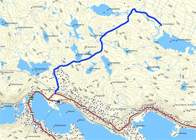
Length: about 7 km.
Map: Can be bought in our shop at Haugastøl. Start off from Haugastøl along the RV 7 towards the railwaystation. Just after the bridge crossing the railway, you will find a road heading off to the left. The route is marked towards Embretstølen by signposts. Follow the path on towards Tjønngravtjørni, or locally known as the Lillevann Lake, and then head off northeasterly towards Embretstølen. The path goes along Kvasshovd and onwards to the Langetjern Lake. This is a lake where you are allowed to fish with a fishing card that you can buy at the reception at Haugastøl. The Embretstølen Cabin is not open for the public. From here you can carry on down towards Ustaoset.
Halne - Sleipa - Heinseter - Fagerheim
Length: 30 min boattrip from Halne to Sleipa. 1,5 Hour from Sleipa to Heinseter and 4 hours from Heinseter to Fagerheim. Halne is located about 20 minutes away from Haugastøl. You are dependt on transport either by bus or by car to make this trip.
Map: Can be bought in the reception at Haugastøl. For a different adventure, book a trip with the Halnekongen Boat. This will ship you across Halnefjorden, a lake located only 18 km along the RV7 from Haugastøl Turistsenter. The boat will drop you off at Sleipa. A path starts from here and leads you up to the Heinseter Cabin. This trips takes approximately 1,5 hours. It is possible to return to Sleipa from Heinseter and catch the Halnekongen Boat back across the lake, or to carry on from Heinseter down to Lappsteinen and Fagerheim Fjellstue. The hike from Heinseter to Lappsteinen takes approximatly 4 hours to walk. Please visit www.halnekongen.no for timings and booking. It is also a nice journey to only follow the Halnekongen to Sleipa and back again across the Halnefjorden. This trip is suitable for people of all ages and of all levels of fitness.
Haugastøl - Lordehytta/Folarskardet
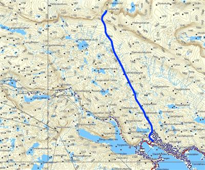
Length: about 12 km.
Map: can be bought in the reception at Haugastøl.
If you like to fish, then bring your fishing rod on this trip. You will pass by many nice lakes with good fishing. Remember to buy a fishing card in the reception at Haugastøl before you go. The path starts on the right hand side of the Tjønngravtjørni Lake (locally known as Lillevann) 1098 meters a.s.l. This is a path marked by red Ts that leads you through Folarskaret and down to Raggsteindalen. It carries on past Bjørnbulægret and onwards to the Lordehytten Cabin. The Lordehytten is a stone cabin built in 1880. The irish Lord John Garvagh d.y. wanted the cabin built, and made it happen by the help of one of the locals, Lars Lein from Hovet. The cabin lays at 1620 meters above sea level in the Folarskaret Gully, almost on the top of the famous Hallingskarvet Mountain Range. The cabin is only accessible by foot. It takes about 3 hours to walk here from Haugastøl. The Lordehytten is included in the Hallingskarvet National Park which is officially opened on the 9th of August 2008. Every August there is a organized hike from Raggsteinddalen to Lordahytta and continuing to Haugastøl named Lordemarsjen. You can read more about this on www.lordemarsjen.no. For the fittest of you, a challenge is to get to the top of the very plateau of Hallingskarvet. However, do not temt to do this unless the conditions are good.
Prestholt Round
Initially, the round was a project designed to repair the damage from traffic on the trail from Prestholtseter up through Prestholdtskardet. The thought was that by facilitating traffic in one area, it would protect nature in the other areas. The work was started in 2011 and finished in 2014.
From Prestholt, large parts of the trail are laid with stone up to the top of Prestholtskardet. From there, it is cairn-marked up to Skarvsenden and top-marked at 1,705 meters elevation where there is a fantastic view. The cairns continue downward toward Vesleskardet, where the Sherpas built approximately 200 meters of trail in 2014. This makes it possible for virtually everyone to get down the steep part without injury. The trip is a total of 6.5 km and also passes an old hunting trap for wild reindeer at the end of the Hallingskarvet. An information poster is set up there.